Update 31.12.2010:
Lately in November SQL Developer 3.0 EA is out integrating the "Map View" already.
Suggest to Download SQL Developer 3.0 !
----------
An update has recently been made for the GEORAPTOR extension in a sourceforge project.
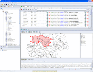
GEORAPTOR is a "viewing component" for the SQL Developer 2.1 to have a first impression of the spatial data used.
You may find more info in my older post here.
BTW:
The name GEO-RAPTOR originates from the former "development" - name of SQL Developer, which was called: RAPTOR (;-)
Hier findest Du Infos zu Oracle Maps und Oracle Spatial/Mapviewer Themen. Viel Spaß damit. Here you will find interesting things about Oracle Maps and Mapviewer I came across. Have fun !
28 January 2010
Oracle and SUN - Oracle will invest additional $ 1,5 Billion in R&D
Please enjoy with me yesterdays' Webcasts of the Oracle Management regarding the new Oracle/SUN Strategy - these are now ready in a recorded version.
In the course of the SUN acquisition Oracle plans to increase the Research & Development budget by one third. The investments will increase by USD 1,5 billion to USD 4,3 Mrd, President Charles Phillips said on the yesterday event.
My Favorites are:
Charles Phillips (general strategy)
Thomas Kurian (Software strategy) and ofcourse ...
Larry Ellison (answers various questions).
Enjoy !
here is the link to all recorded webcasts (Flashplayer required)
07 January 2010
Mapviewer 11.1.2 is out
The new Mapviewer 11g in its Version 11.1.2 is ready for download.
The release notes can be found here:
It incorporates a.o. flwg. enhancements:
Enhancements =================================================================
o Native support of Google Maps and Bing Maps API. You can now display
Google and Bing maps natively in your Oracle Maps (JavaScript)
applications. Please check out the online Oracle Maps JSDoc API on
how to use the new classes.
o Internationalization support has been added to label columns of
pre-defined themes. You can now supply translated labels for your
predefined themes. Check out the user's guide for more details
(section 2.3.1.6).
o Line style: Support for multiple arrows or markers at start and end
points, or at all vertexes of line.
o Improved street name labeling where sometimes glyphs may overlap
each other in earlier versions.
o Server status monitoring page. After logging into MapViewer's admin
page, you can open /mapviewer/admin.html to view various statistics
such as up time, longest running theme queries, connection and
memory usage and other data.
o Map Builder now starts with "no connection" as the default mode.
o The built-in proxy servlet (for cross-site scripting support) has
been hardened to allow only redirect URLs specified in the
mapViewerConfig.xml file.
Bug fixes ====================================================================
o Fixed a bug that sometimes causes JVM to crash (BUG 9118738)
o Fixed several bugs related to Wrap-Around map when using the Oracle
Maps JavaScript API. Note, there are still several known issues
regarding wrap-around map, particular when used in conjunction
with third party mapping services.
o BUG 9050313 - CONTINOUSLY ZOOMING THE MAP WITH MOUSE WHEEL RESULTS
IN TOO MANY MAP REFRESHES
o Fixed a bug so that you can now reference marker icons by URL.
o Fixed a bug regarding WFS requests when the base URL contains
additional parameters
o BUG 9006435 - MAP PRINTING IGNORES MARKER FOI
o BUG 8921639 - MVStyleMarker CANNOT HANDLE RELATIVE URLS
o BUG 8845558 - MVTHEMEBASEDFOI.SETQUERYPARAMETERS RESULTS IN JS ERROR
WHEN A PARAMETER IS NULL
o Fixed several Redline tool related bugs.
o BUG 8705614 - MAP MOUSE_CLICK EVENT IS FIRED WHEN THE MAP IS DRAGGED
o BUG 8606370 - MAPVIEWER PROXY SERVLET DOES NOT CHECK REDIRECT URLS
o Fixed a bug so that a non-default WebLogic admin user can also be used
to log into MapViewer's Admin page.
o BUG 9077317 - WMS THEME IS NOT RENDERED PROPERLY IN TILE REQUESTS DUE
TO WRONG MBR CAL
o Fixed a bug where the internal geometry cache will leak memory if
user requests a metadata cache purge (BUG 9088090).
o Fixed a bug where MapBuilder sometimes cannot load a TTF font file;
and when it loads, only the first 255 glyphs are displayed.
o Removed MapViewer-specific session timeout setting from its web.xml;
now MapViewer will always use container's default session timeout
value.
o Fixed a bug (9203727) where sometimes MapViewer creates unnecessary
sessions.
Good luck with that one !
Subscribe to:
Posts (Atom)