- XE Express Edition (kostenlose Edition mit ein paar Einschränkungen)
- SEO Standard Editon One (1 Rechner - max 2 CPU)
- SE Standard Edition und
- Enterprise Edition (Übersicht der Oracle Server Editions hier)
Die Antwort zu "Was geht mit dem Locator?" hier in der Doku.
Dort ist auch grob (am Ende) angerissen, wofür die Spatial Option erst zusätzlich zur EE zu lizensieren ist.
Die Funktionsübersicht von Oracle zum Locator (gegenüber der Spatial Option) besagt:
+ Query nearest neighbor and other spatial relationships between geometries
+ Perform location queries on relational information not stored in Oracle Spatial geometry
+ Support long transactions
+ Store and index vector geometries in the database
+ Enhance application performance
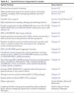
Ein Auszug aus dem Oracle® Spatial User's Guide and Reference
10g Release 2 (10.2) - Anhang B - hier:
In general, Locator includes the data types, operators, and indexing capabilities of Oracle Spatial, along with a limited set of the functions and procedures of Spatial.
The Locator features include the following:
An object type (SDO_GEOMETRY) that describes and supports any type of geometry
A spatial indexing capability that lets you create spatial indexes on geometry data
Spatial operators (described in Chapter 11) that use the spatial index for performing spatial queries
Some geometry functions and the SDO_AGGR_MBR spatial aggregate function
Coordinate system support for explicit geometry and layer transformations (SDO_CS.TRANSFORM function and SDO_CS.TRANSFORM_LAYER procedure, described in Chapter 13)
Tuning functions and procedures (SDO_TUNE package, described in Chapter 19)
Spatial utility functions (SDO_UTIL package, described in Chapter 20)
Integration with Oracle Application Server 10g
For information about spatial concepts, the SDO_GEOMETRY object type, and indexing and loading spatial data, see Chapters 1 through 4 in this guide. For reference and usage information about features supported by Locator, see the chapter or section listed in Table B-1.
Im Zweifel bitte genau in den User Guide schauen und/oder bei Oracle zurückfragen, wenn es um die korrekt Lizensierung geht.
Hier noch die Übersicht aus dem Oracle Spatial 10g Ref.-and User Guide:

